
Where Is Mount Kailash Located?
A Complete Guide to Its Sacred Location
Mount Kailash is one of the most sacred and remote mountains on earth — revered by over a billion people across four religions, yet visited by only a few thousand pilgrims each year. Before planning the journey, the first question almost everyone asks is the most fundamental one:
Where exactly is Mount Kailash — and how do you get there?
This guide answers both in full. You will find the precise location, coordinates, surrounding geography, the four sacred rivers, the spiritual significance for each faith, and a complete breakdown of every route used to reach the mountain in 2026.
Mount Kailash Location — Quick Facts
| Country | China (People’s Republic of China) |
| Administrative region | Tibet Autonomous Region (TAR) |
| Prefecture | Ngari Prefecture (Burang County) |
| Coordinates | 31.0675° N, 81.3119° E |
| Elevation | 6,638 m (21,778 ft) |
| Mountain range | Gangdise Shan (Kailash Range), part of the Transhimalaya |
| Distance from Lhasa | Approx. 1,200 km (overland via G219) |
| Distance from Kathmandu | Approx. 900 km overland via Gyirong border |
| Nearest base town | Darchen (4,675 m) — starting point for the Kora |
| Nepal border (nearest) | Approx. 100 km south (Humla district) |
| India border (nearest) | Approx. 90 km southwest (Lipulekh Pass, Uttarakhand) |
| Climbing status | Unclimbed and climbing is prohibited |
| Sacred to | Hinduism, Tibetan Buddhism, Jainism, and Bon |
Where Exactly Is Mount Kailash?
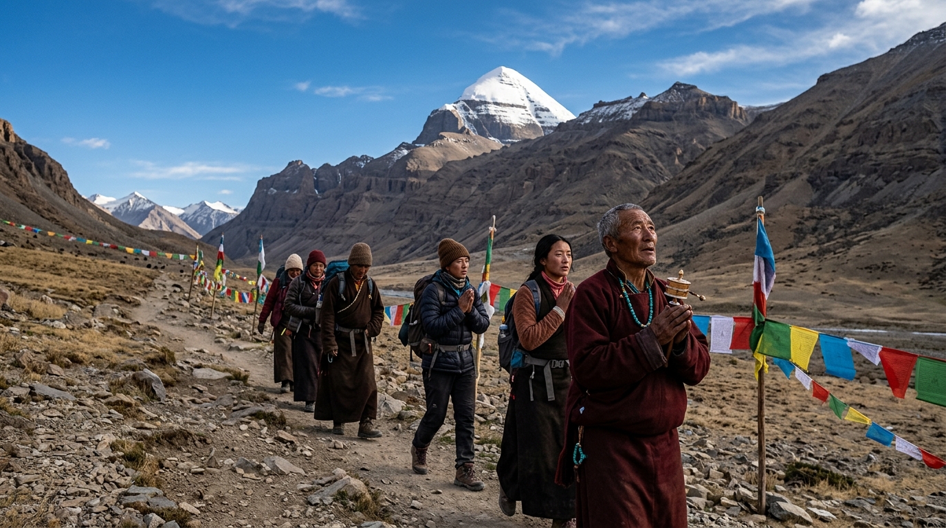
Mount Kailash sits in the far western corner of the Tibet Autonomous Region, in Ngari Prefecture — the most remote and least populated administrative area in Tibet. Its exact coordinates are 31.0675° N latitude and 81.3119° E longitude, placing it in Burang County, well inside the borders of China.
The mountain is part of the Gangdise Shan — also called the Kailash Range — which runs roughly northwest to southeast and forms part of the Transhimalaya, the vast mountain system that runs parallel to and north of the main Himalayan chain. Unlike the snow-heavy central Himalayas, the Gangdise Range sits in a rain shadow zone, giving it a distinctively stark, rocky appearance that contrasts with the brilliant white of Kailash’s own pyramid-shaped peak.
At 6,638 m (21,778 ft), Mount Kailash is not the tallest mountain in the region — the highest peak in the Kailash Range is Lunpo Gangri at 7,095 m. But Kailash’s almost perfectly symmetrical four-sided pyramid, its permanent snow cap visible from vast distances across the plateau, and its untouched, unclimbed status give it an immediate visual power unlike any other peak in western Tibet.
Is Mount Kailash in India or China?
Mount Kailash is located entirely within China — specifically in the Tibet Autonomous Region. It is not in India, Nepal, or Bhutan.
The confusion arises because of geography and spiritual history. The mountain sits very close to the trijunction where China, India, and Nepal meet. The India-China border at the Lipulekh Pass in Uttarakhand is approximately 90 km to the southwest. The Nepal border at the Humla district is approximately 100 km to the south. This proximity means that for centuries, Indian and Nepali pilgrims have crossed these borders to reach the mountain — and many people associate Kailash with South Asian culture and religion. But the mountain itself has always been on the Chinese side.
Note: Kailash Parvat (the name most commonly used in India) and Mount Kailash (the name used in English and internationally) are the same mountain. Gang Rinpoche and Kangrinboqê are the Tibetan names used locally.
The Geography Surrounding Mount Kailash
Mount Kailash does not stand alone. It is the centrepiece of a remarkable geographical cluster that amplifies its spiritual significance.
Lake Manasarovar
Approximately 30 km southeast of Kailash lies Lake Manasarovar — one of the highest freshwater lakes in the world, sitting at 4,590 m above sea level. The lake is roughly circular, approximately 88 km in circumference, and fed by glacial meltwater from the surrounding peaks.
In Hindu tradition, Manasarovar was created in the mind of Lord Brahma — its name combines “manas” (mind) and “sarovar” (lake). Bathing in its waters is believed to cleanse a lifetime of sin and prepare the body for the Kailash Parikrama. Many pilgrims perform a circumambulation (parikrama) of the lake itself before beginning the Kailash Kora.
In Tibetan Buddhism, Manasarovar is the manifestation of the pure mind of enlightenment. Its waters are considered sacred for rituals, and monasteries line its shores including the ancient Chiu Monastery on the northwest bank.
Lake Rakshastal
Directly west of Manasarovar lies Lake Rakshastal, a salt lake at similar altitude. Where Manasarovar is fresh and still, Rakshastal is saline and windswept. In Hindu tradition it is associated with Ravana, the demon king — its name means “devil’s lake.” Together, Manasarovar and Rakshastal represent the eternal cosmic balance of good and evil, sacred and profane, positioned side by side in the shadow of Kailash.
The Four Sacred Rivers
One of the most remarkable geographic facts about Mount Kailash is that four of Asia’s greatest rivers originate within approximately 60 km of the peak — flowing outward in the four cardinal directions:
| River | Direction | Flows to | Countries served |
| Indus (Sengge Khabab) | North | Arabian Sea | Tibet, India, Pakistan |
| Sutlej (Langqen Khabab) | West | Arabian Sea | Tibet, India, Pakistan |
| Yarlung Tsangpo (Brahmaputra) | East | Bay of Bengal | Tibet, India, Bangladesh |
| Ghaghara (Karnali tributary) | South | Bay of Bengal (Ganges) | Tibet, Nepal, India |
These four rivers drain the entire Indian subcontinent and support more than a billion people. That four of the world’s most significant river systems originate from within the same small geographical zone — all within sight of the same sacred peak — has reinforced Kailash’s identity as the centre of the world in multiple religious traditions for thousands of years.
Mount Kailash Spiritually Significant
No other place on earth is simultaneously sacred to four of the world’s major religions. The significance of Kailash’s location is inseparable from its spiritual identity.
Hinduism
In Hindu cosmology, Mount Kailash is the earthly manifestation of Mount Meru — the cosmic axis around which the universe revolves, described in the Puranas, the Mahabharata, and the Ramayana. It is the abode of Lord Shiva and his consort Goddess Parvati, where Shiva sits in eternal meditation. Hindus circumambulate the mountain clockwise (the direction of all sacred Hindu rituals) and believe that completing the Kora washes away the sins of a lifetime. The Kailash Mansarovar Yatra is considered among the most important pilgrimages in Hinduism.
Tibetan Buddhism
Tibetan Buddhists regard Kailash as the dwelling place of Demchok (Chakrasamvara), a deity of highest tantric practice, and his consort Dorje Phagmo. The mountain is called Gang Rinpoche — “precious snow mountain.” In Buddhist cosmology it represents Mount Sumeru, the centre of the universe. The great Tibetan saint Milarepa is said to have meditated in caves on and around the mountain, and the Kagyu tradition in particular holds Kailash as a supreme site of enlightenment. Tibetan Buddhists also walk clockwise.
Jainism
Jains call the mountain Ashtapad and believe it is the site where Rishabhadeva — the first of the 24 Tirthankaras (spiritual teachers) of Jainism — attained moksha (liberation). This gives Kailash a foundational role in Jain cosmology comparable to its role in Hindu and Buddhist traditions. Jain pilgrims traditionally circumambulate counterclockwise.
Bon
Bon is the pre-Buddhist indigenous spiritual tradition of Tibet. In Bon cosmology, Kailash — called Tise — is the great nine-story swastika mountain from which the founder of Bon, Tonpa Shenrab, descended to earth. It is the axis of the Bon universe and the most sacred site in all of Bon practice. Bon practitioners circumambulate counterclockwise — the opposite direction to Hindus and Buddhists — and their route visits different sacred sites than the standard Kora.
Why Has No One Climbed Mount Kailash?
Mount Kailash has never been climbed — and unlike Everest, it is not a matter of difficulty. Climbing it is spiritually prohibited.
In 1926, a British expedition reached the base but chose not to attempt the summit out of respect for the mountain’s sacred status. In 2001, the Chinese government announced that Reinhold Messner — the greatest high-altitude mountaineer of the 20th century, first to solo Everest — had been given permission to climb Kailash, but he declined, saying that a man who would climb Mount Kailash for personal glory would deserve to be struck down by lightning. The Chinese authorities have since confirmed that no climbing permits will be issued, citing both religious sensitivity and environmental preservation.
The unclimbed status of Kailash is not a failure of mountaineering. It is a deliberate, ongoing act of reverence shared by four religions, the Chinese government, and virtually every mountaineer who has ever looked at the mountain.
How to Reach Mount Kailash in 2026
Reaching Mount Kailash requires planning, permits, and a licensed tour operator. Individual travel is not permitted — all visitors must join a group tour organised through an authorised agency. Below are the three main routes used to reach the mountain.
| Route | Key waypoints | Drive time |
| Nepal → Gyirong (most popular) | Kathmandu → Gyirong border → Saga → Paryang → Darchen | 6–8 days |
| Nepal → Simikot/Humla | Kathmandu (flight) → Simikot → Hilsa border → Purang → Darchen | 8–10 days |
| Lhasa overland | Lhasa → Shigatse → Saga → Paryang → Darchen | 12–15 days |
Route 1: Nepal to Kailash via Gyirong (Most Popular in 2026)
The Gyirong overland route is the most commonly used route for international travellers. You fly into Kathmandu, where your tour operator handles all Tibet permits (Tibet Travel Permit, Alien Travel Permit, Military Area Permit, and Ngari Permit). The drive crosses the Nepal-China border at Gyirong (Rasuwa), then travels west through the high Tibetan plateau — passing Saga and Paryang — to arrive at Darchen in approximately 6–8 days depending on acclimatisation stops.
This route is scenically spectacular. You cross from Nepal’s green hills into the wide open landscape of the Tibetan plateau in a single morning. It is also the route with the best permit processing infrastructure from Kathmandu, making it the recommended starting point for most travellers.
Route 2: Nepal to Kailash via Simikot and Humla
The Simikot route is shorter in driving distance but requires a domestic flight from Kathmandu to Simikot, followed by a trek to the Hilsa border crossing into Tibet. From Hilsa, a drive through Purang county reaches Darchen. This route passes through the most remote corner of Nepal and Tibet, with dramatically different landscapes from the Gyirong route.
The Humla route is ideal for travellers who want a less crowded, more adventurous approach to Kailash. It is also historically significant as one of the oldest pilgrimage routes used by Indian and Nepali pilgrims for centuries before road infrastructure existed.
Route 3: Lhasa Overland (via Friendship Highway)
Starting from Lhasa, this route follows the G318 Friendship Highway west through Shigatse, often including a detour to Everest Base Camp at Rongbuk Monastery. From Tingri the road heads southwest to Saga, then west to Paryang and Darchen. The full journey from Lhasa to Darchen takes 12–15 days and is the most comprehensive Tibet tour option.
This route is popular for travellers who want to experience Lhasa, the Potala Palace, Yamdrok Lake, and Gyantse before reaching Kailash. It is the longest but arguably the most culturally immersive approach.
Permits Required to Visit Mount Kailash
No visitor can enter the Tibet Autonomous Region independently. The following permits are required and must be arranged through a licensed tour operator:
- Tibet Travel Permit (TTP) — required for all foreigners entering Tibet
- Alien Travel Permit (ATP) — required for the Ngari region
- Military Area Permit — required for border areas near India and Nepal
- Ngari Prefecture Permit — specific to the Kailash and Manasarovar area
All permits are processed through your licensed tour operator in Kathmandu or Lhasa. Processing time is typically 10–15 working days from Kathmandu. Individual travellers cannot obtain these permits on their own.
Best Time to Visit Mount Kailash
- The Kailash region is accessible from May to October. Outside these months, the roads into western Tibet are frequently impassable due to snow and extreme cold.
- May to June: Clear skies, moderate temperatures, and the sacred Saga Dawa festival (Buddha’s enlightenment) — the most auspicious time to complete the Kora. Very busy.
- July to August: Monsoon season. Some rainfall, reduced visibility, but still accessible. Prices slightly lower.
- September to October: Post-monsoon clarity, excellent mountain views, cool temperatures. Many consider this the best season overall.
- November to April: Tibet border crossings often closed or restricted. Not recommended for Kailash specifically.
Frequently Asked Question
Is Mount Kailash in India or China?
Mount Kailash is in China — specifically in the Tibet Autonomous Region, Ngari Prefecture. It is not in India or Nepal, although the mountain sits approximately 90 km from the Indian border (Uttarakhand) and 100 km from the Nepali border (Humla district). The confusion is common because of its deep spiritual importance to Hinduism and the long history of Indian and Nepali pilgrims crossing into Tibet to reach it.
What are the coordinates of Mount Kailash?
The exact coordinates of Mount Kailash are 31.0675° N latitude and 81.3119° E longitude. It lies in Burang County, Ngari Prefecture, Tibet Autonomous Region, China.
How far is Mount Kailash from Kathmandu?
The overland distance from Kathmandu to Darchen (the base of Mount Kailash) via the Gyirong border crossing is approximately 900 km. The drive takes 5–7 days, with acclimatisation stops along the way. Flying to Lhasa and driving west takes longer in total — approximately 10–12 days of travel.
Why is Mount Kailash never climbed?
Mount Kailash has never been climbed because climbing it is considered an act of profound disrespect by all four religions that regard it as sacred — Hinduism, Tibetan Buddhism, Jainism, and Bon. The Chinese government has officially prohibited climbing permits to protect both the mountain’s religious sanctity and its fragile environment. Mountaineers including Reinhold Messner have publicly declined the opportunity to climb it out of respect.
Can you see Mount Kailash from Nepal?
Mount Kailash is not visible from most of Nepal because it sits well inside the Tibetan plateau, north of the main Himalayan chain. It is, however, visible from the Humla district of far northwest Nepal on exceptionally clear days — though the view requires altitude and favourable weather. The better views come from within Tibet itself, particularly from the Kailash Kora trail.
Is Mount Kailash the same as Kailash Parvat?
Yes. Kailash Parvat, Mount Kailash, Gang Rinpoche, Kangrinboqê, and Tise are all names for the same mountain. ‘Kailash Parvat’ is the name most commonly used in India (parvat means mountain in Sanskrit and Hindi). ‘Gang Rinpoche’ is the Tibetan name meaning ‘precious snow mountain’.
What religion considers Mount Kailash most sacred?
All four religions — Hinduism, Tibetan Buddhism, Jainism, and Bon — hold Kailash as supremely sacred, each for distinct reasons. In terms of sheer number of pilgrims, Hindu tradition generates the most travellers due to India’s population. In terms of geographic closeness to the mountain, Tibetan Buddhism has the longest continuous tradition of pilgrimage and monastic presence in the region.
What is the nearest town to Mount Kailash?
Darchen (4,675 m) is the base town for Mount Kailash and the starting point for the Kailash Kora (circumambulation). It has guesthouses, small restaurants, a medical post, and permit checkpoints. Purang (also called Burang) is the nearest larger town, approximately 100 km south, near the Nepal and India borders.
Can Indian citizens travel to Mount Kailash?
Yes, Indian citizens can travel to Mount Kailash, most commonly via the Kailash Mansarovar Yatra — a pilgrimage route historically facilitated between the governments of India and China. The route via Lipulekh Pass (Uttarakhand) and the route via Nathu La (Sikkim) have been operational in past years, though availability and permit conditions vary by year. In 2026, Indian pilgrims should verify current route status with their tour operator before booking.
How long does it take to get to Mount Kailash from Kathmandu?
The overland journey from Kathmandu to Darchen via the Gyirong border takes approximately 5–7 days of driving, including necessary acclimatisation stops in Saga and Paryang. Total tour duration including the Kailash Kora (3 days) and the return journey is typically 12–15 days from Kathmandu.
Recent Posts
Mount Kailash Kora Distance and Difficulty
Where Is Mount Kailash Located?
Common Visa Mistakes for Mount Kailash Trip
Kailash Yatra Permit Processing Time from Kathmandu
Required Permits for Mount Kailash Trip by Route
Do You Need a Visa for Mount Kailash Trip
Visa for Mount Kailash Trip
Age Limit for Mount Kailash Yatra
Mindful Trip to Mount Kailash